On March 3rd 2014 a cruise ship measuring
535 feet, 66 feet wide and a draft of 5 meters dropped two big anchors and hundreds of feet of chain onto the grassy and sandy sea bed inside Falmouth Harbour, a,,,marine protected area. For some time now residents, charservationists have been calling for the authorities to stop this vessel from coming into the Harbour for a host of reas ons.
Some of the reasons have been environmental concerns based on the fact that the area is a foraging zone for green as well as hawksbill sea turtles, both endangered species. According to the National Parks Website,
"The marine environment is home to several different species of Seagrass,
the two dominant species being Turtle Grass and Manatee Grass.
Seagrasses are flowering marine plants, which photosynthesize and are
hence limited to growth in depths and areas where they have access to
sunlight. They provide habitat for many marine species, including
juvenile and adult fish as well as crustaceans. Furthermore, these
seagrasses sustain many species, including the Green Sea Turtle.
Seagrass also serves to reduce the force of the waves before the get to
the coastline. Seagrass beds can be found adjacent to most beaches
within the park boundaries."

Since this cruise ship started anchoring in the bay there have been turtles washing up dead to the lee and some suggest that the ship could be responsible. I am not too sure that this is true but their high speed tenders often
are seen zooming up and down right though the area where the turtles are
feeding. They have quite an array of tenders which are launched from aft as seen in the image below taken from their website.
The image is of one of several dead turtles found washed up during and shortly after the cruise ship has been in the harbour.
There is no way to prove that the ship was responsible for killing these turtles, but there can be no disputing that the area is a valuable foraging area for these species just as the National Parks website suggests. In fact, tour boats like mine often take tourists to see the turtles exactly in the area where the ship has been anchoring.
Another smaller turtle found the morning after Wind Surf had been in the harbour. Notice the damage to it's shell. This is a young green turtle.
Here is a shot of a Navionics Chart which shows the area we are speaking of. Notice the scale in the bottom right of the image. Click on it for a larger version. By the way the soundings are measured in meters. It's very important for the rest of this blog to note the depth on the right hand side of the image between the two red markers. That depth is under 5 meters and the lower of the two marks keeps vessels clear of Bishops Reef. Remember this 535 foot ship has a draft (under the waterline) of 5 meters according to their company website. The grassy beds are scattered throughout the harbour and especially where the ship lays on her huge anchors.

On the morning of March 3rd, she anchored up as she has normally done in recent months with her two big anchors off to the east close to the entrance of the marked harbour entrance. Wind Surf sat just upwind of Dieppe Bay with only a few feet water below its keel. The image below was taken after Wind Surf anchored in her normal position. In the image below taken at 12:04 PM you will notice two other ships outside of Falmouth Harbour sitting on their anchors facing towards the prevailing easterly winds which are normal. However, this photo was taken moments after a very strange weather event. The winds had just switched to the west-south-west. The smaller boats in the Harbour had already swung on their moorings to face the light westerly winds. The three bigger ships were just starting to swing.

In this next two images below taken over thirty minutes later, the outer ships had swung right around on their anchors like all the other vessels inside Falmouth Harbour (the damage being done to the reef out there is shameful, but that's another story). The photographer had watched the ship slowly drift around on its anchors until came to a stop where it sits in images before. The 535 foot Wind Surf is the only vessel not pointing into the wind in this photo. It also can not be seen to be using any great propulsion to hold her in place. She is only using anchors at the bow. What is holding her in position and preventing her from swinging 180 degrees as all the other vessels have done? Well the answer lies in analysis of the position she is found in relation to the little red marker to her aft. It is difficult to see the actual position in the image below even when you have clicked on it for a larger version.
Click here for a larger version.
As you can see she still remains in the same position in this second image taken a short while later from a slightly different position.
Click here for a larger version.
The photo below was also taken at the time when I was alerted by several people that she was "aground".
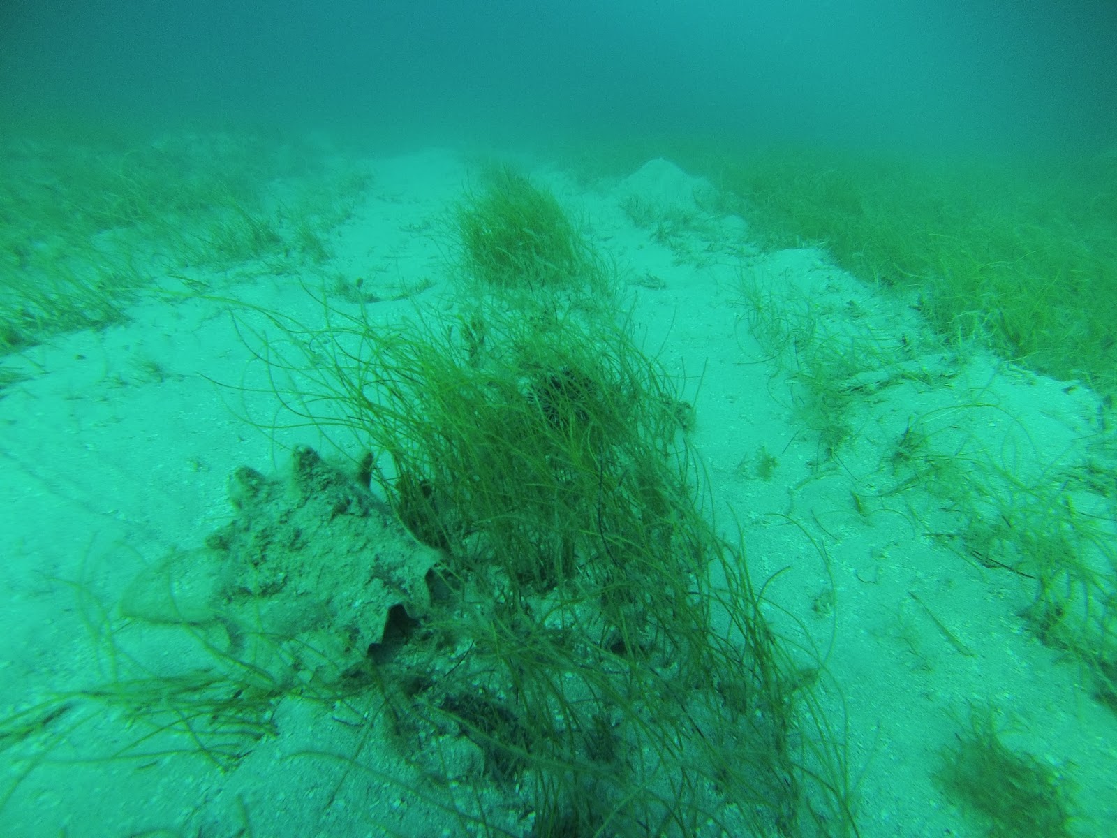
Click here for a larger version and please take careful note of the position of the red Bishops Reef mark behind and slightly to port. Most experienced captains who looked at the image below remarked that she looked like she was listing slightly to starboard. Remember that this vessel draws 5 meters and that according to current navigational charts the depth there is between 5 and 6 meters and rapidly getting shallower up to 2 meters immediately on her starboard side. In the photo below her port side anchor is tight against the hull pointing to starboard. The vessel can not go forward in that position and as you can see the silting has started to envelope the harbour. The vessel is doing damage to the marine life there by blanketing corals and sea grasses with silt while she the captain tries to prevent her from being damaged on Bishops Reef which is where the wind was carrying her along the 180 degree swing which all the other vessels including the two cruise ships outside the harbour had just done. The seabed directly under the vessel where she sits in the photo is mostly turtle grass and sand. Video taken the next day shows crushed conch shells and considerable scarring of the sea floor.

Here are a few of the great many images taken. As you can see, the National Parks Authority is correct about identifying turtle grass eaten by the green turtles and many other organisms. Notice the queen conch in the freshly dug up seagrass bed. A little further up there was a crushed conch. We will save that photo and vidoe for a later date.
My old buddy Nathan Dundas is the ship's agent and was quoted in the newspaper as saying essentially that the boat didn't touch the bottom, that no turtles forgage in the area and none of their habitat is or has been damaged. There is no question at all that the unusual weather on the 3rd caused the ship to brush up against the sea floor just adjacent to Bishops Reef's mark and that the intense propulsion used to get out of the dangerous position caused considerable silting of the reef and other organisms.
This photo below was taken after one pm and shows a bit of the silting that I am speaking of. By this time they have gotten the ship into deeper water.
"Coral polyps, although able to withstand
moderate sediment loading, cannot displace heavier loads and perish through
suffocation." This was taken from the United Nations Environment Program's site. This level of silting is what you expect during dredging and other heavy construction and every effort to prevent it from coming into contact with fragile ecosystems. As the national parks confirms in their site, turtle grass needs sunlight to live. The photo below shows plenty of sand and silt churned up which is now blanketing corals and grasses. That equates to damage. How can this be disputed by reasonable people? John Maginley, our Minister of Tourism says that what the ship did was nothing out of the ordinary and the same level of silting you would expect after a good rain. I think he is clearly mistaken as is Mr. Dundass. Both people have said that the suggestion that damage was done in unfounded and that the ship didn't touch the bottom. These are some of the photos that we have which we expect proves otherwise. We have reams more evidence including video. We didn't want to publish any of this but the recent articles in Caribarena, The Observer and Antigua Chronicle coupled with statements made on facebook by the Minister forced us to shed a little more light on what happened the other day. Maginley has been telling people and writing on facebook threads that the owners of the ship are going to be taking legal action against me and the Daily Observer for an article where I am quoted as saying that the ship was aground and that The National Parks Authority and Port Authority should not permit a vessel of this size in Falmouth Harbour. I was also quoted as saying that conservationists and residents have been complaining about this ship and the damage that it has been doing to the authorities for months. In fact, I even had a conversation with Minister Maginley about this before the new year. I still stand by what I said and will wait for the court case.

A few more photos for good measure. The first two from the day in question and the other two from another visit.