Showing posts with label storms. Show all posts

Thursday, June 25, 2009

It's hurricane season in the Atlantic again.

DSC00509sm
Actually it's been hurricane season since June 1st and as is normal, the Atlantic hasn't seen a named storm yet. The very old hurricane season rhyme went like this:
JUNE too soon
JULY Standby
AUGUST come it must
SEPTEMBER remember
OCTOBER all over

I am not sure if in the old days weather was very different, but as long as i have been alive this rhyme has been a month off. June and July in the Caribbean are as described in the Rhyme, but August and September should be grouped together with September being a far more active storm month than any other month.
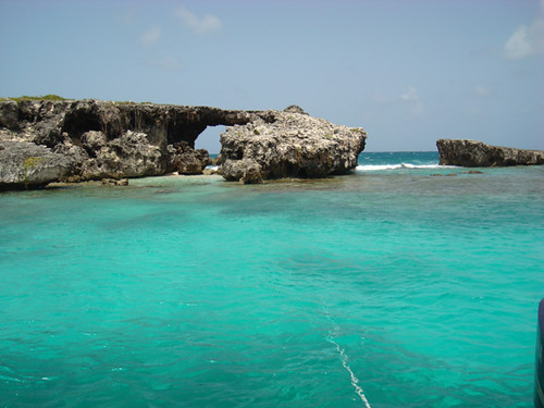
We have also learned that October isn't totally all over, and if i remember correctly 2 of the 6 hurricanes that we have been hit by since the 1950s hit us in October. Anyway, the ryhme is a good guide when making plans for a sailing cruise through the Caribbean (as i am at the moment). In between storms which can occasionally pass the weather in the summer is the best all year in my opinion with beautifully clear waters and calm seas.
Interestingly, Antigua has only been directly hit by 6 hurricanes since the mid 1950s and I think all six happened in August, September and October. We have had many close calls and even some very bad weather from the cloud bands coming off hurricanes passing well to our North or South as in the case of Omar last year. Sometimes the only storm conditions we get are huge surfing waves which have been pushed in from hundreds of miles away where a passing storm is churning up the ocean.
In my lifetime, the worst hurricane we got was Hurricane Louis or Luis as it has now been called. That was a cat 5 when it hit according to the US Navy base which was here at the time but what was the worst thing about it was the fact that it was moving slowly. We had hurricane force winds for a day and tropical storm force winds or more for nearly two days. Many houses had damage and most hotels did as well. Both my mom's and my dad's houses fared well in that storm proving that if built well, wood can hold up.
Anyway, the first "blimp on the radar" was picked up by one of the super computer models yesterday (read more about these "models" and how hurricane forecasting is done here).
My good friend Steve mentioned on facebook that he had read on Crown Weather that there was something being detected. Here is today's weather discussion on this private weather site. Click here.
"
Interest Area 2: Another area I am closely watching is completely based on the GFS model. An area of impressive looking shower and thunderstorm activity is located over western Africa this morning. The GFS model insists that this convective complex will develop into a tropical cyclone as soon as this weekend. None of the other global models are forecasting development across the eastern Atlantic, so I remain pretty skeptical that it will happen. Also, the GFS model has been doing very poor with tropical cyclone forecasts so far this season in that it has been forecasting false storms and handling upper level patterns very poorly. So with no other real model support, I am pretty skeptical that this will indeed happen.

With that said, the environmental conditions are favorable for development and will remain favorable for at least the next few days. Sea surface temperatures, however, are actually below normal across the eastern Atlantic and this would inhibit development until this disturbance approaches the Lesser Antilles during Wednesday and Thursday of next week where sea surface temperatures rise to above normal for this time of year.

So, with all of this said, there is the possibility of something to watch in the eastern Atlantic this weekend into next week, but I have very low confidence of it actually happening.
"

I also think that it's kinda early for that type of thing. I also think that the massive amount of African dust in the air at the moment will do as it normally does and stop any storm from getting strong. Read more on African dust coming across the Caribbean here. In that blog post there is a link showing how this increased dust levels kill storm production. Interesting stuff. Anyway, I am not cancelling my sailing plans just yet. This time next week i hope to be 200 miles from home in the BVI enjoying Pussers Pain Killers!

Wednesday, July 09, 2008

Understanding Windguru and weather in Antigua

Here at Adventure Antigua weather forecasting is an essential tool used in our business. Yesterday we had a tough one with some bad weather that rolled in. We sat glued to weather maps, radar, and satellite images on the computer before we made the decision to postpone two boat trips for the day until thismorning. As someone who monitors weather every day and then has to send several boats out, i see what forecasts work and what doesn't. No site is 100% accurate, and many are total garbage. Dont ever use yahoo wather or weather.com's animated forecasts. I have never seen them say we would have a sunny day here in Antigua. The most simple forecasting site giving long range forecasts that has the highest degree of accuracy for Antigua and Barbuda is windguru. Coming from 17 years of competitive windsurfing i can tell you that there isn't a group of more addicted wind and wave junkies that windsurfers, and windguru was set up by a bunch of them. When i first heard about it i thought there was no way that these guys from Czech republic could tell me what weather i could expect in Antigua next week. All my friends were telling me that it worked so i added windguru to my favorites and started checking each day. It's been years now and they have been incredibly accurate predicting cloud cover, rain, winds, and waves. They are are also accurate at predicting wave direction and wind direction. The forecasts are so good that i think our local forecasters here should just tell people what windguru is forecasting before doing or saying anything else. So often windguru will forecast a weather event like strong winds or big rain or huge waves and we say to each other: ''Windguru has gone mad again as there are no storms forming and nothing out there''. We then have to eat our words a few days later when a storm forms a thousand miles away and things start to look like they will be right. Last year was the best though when a week before Hurricane Dean appeared it was forecast by windguru. Everyone thought that windguru had gone mad until they saw the clouds coming together on sat maps.
Anyway, i keep hearing people say they find it difficult to understand windguru. According to their site: ''WindGURU is a service specialized for forecasting weather, mostly for windsurfers and kitesurfers (but not only...). Forecasts are based on data produced by weather forecast models. Windguru is able to provide forecast for any place on planet Earth. The main reason to create this site was the idea to get the forecasts quickly and easily without wild clicking the mouse while searching for meteomaps throughout the internet.''
So it should be easy and i want you to figure it out.
Using Windguru's seven day forecasting tool:
Go to the website and using the drop down menus for the 'geographic area' locate the Caribbean. Then go to the country and select the Antigua and Barbuda one. Then below that you see a menu for 'Spot', select Antigua and press 'GO'. You will now have the most accurate forecast for Antigua there is at this point IMHO. Lets show you how to figure the info out. I cut out a bit of the main image and drew a little arrow in the top left corner pointing to the day and date which in this case is today Wednesday July 9th. You can even see the time of day as you look from left to right under the date starting from 5 am and going to the right of the image ending in 8pm.

Ok next we will speak about wind speed and wind direction which are on the line below the time of day. In the image below the red line is pointing to the colourful wind speed box on the far left which forecasted 10 knots at 5 am. By the way you can adjust it to be measured in whatever unit you want from mph to knots to kmph. I like knots and is what i understand. Here is the image:
You can see that by the end of the day it is saying that it will be 13 knots at 20 hours (8pm). Under the colourful wind speed boxes there is a line for wind direction. On the far left it is pointing from right to left using the compass directions. East is on the right and west is on the left. North is up top and south is below. In this case the winds are coming from the East on the right and blowing towards the west. The next thing is something very important for boaters and especially ones that are kept on moorings off beaches at areas where it is normally calm. Many boats here in Antigua would be safer if people would keep an eye during the winter on this part of windguru. Wave height and wave direction. Waves don't always come from the east here in Antigua. The image below shows the red arrow i drew pointing at wave size or height. As you can see at 5 am it was 2.2 meters high and over on the far right at 20 hrs they will be 1.4 meters so the waves are dropping through the day.
Under the wave height line there is the 'wave period' line which tells you how long a particular wave will take to go past a specific point in seconds. A longer wave period (higher number) means the wave is essentially thicker or wider. There is more water in that wave and more power. Higher numbers are good for surfers and bad for your moored boat or beach house in a storm. Below the wave period is the wave direction line which is so important. Here at 5 am you can see that the forecast was for waves coming from the north-east (remember east is on the right and north is up top). This will let you know if your favorite beach will be calm or not. That if you know what side of the island your beach is :)
Temperature, cloudcover and rainfall. The next red arrow i drew points to the most important part of the forecast for many tourists coming to Antigua and Barbuda. The temperature. In Antigua the temperature stays the same for most of the year so i don't ever look at this part of windguru. Here at 5 am it said it would be 28 degrees C and as you can see they say it will be the same all day. Never worry about the temp here in Antigua. Its always warm. Under the temp line is 'cloud cover percentage' which is important for those beach people who want to get loads of sun on their holiday. Today at 5 am it said over on the far left at the bottom that it would have 22% cloud cover. At mid day it would have 50% cloud cover. Under the cloud cover line there is the rainfall line which is important. People always are asking on the internet forums about how much is it raining in Antigua. Here is your answer. Today between 5 am and 8 am they forecast that .5 of a mm would fall on the island and between 8 am and 11 am .4 of a mm would fall again. It didn't happen in Jolly Harbour today but i am sure that somewhere on the island got a 30 second rainfall over the past 6 hours. OK that is how simple it is to get an accurate forecast for Antigua and Barbuda. Just follow these instructions and rest assured that its mostly sunny here in Antigua.