Tuesday, August 25, 2026

The gentrification of Boobie Alley

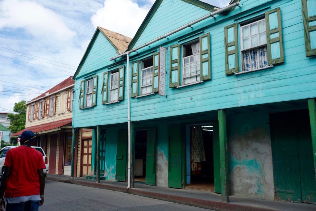
Traditional wooden buildings in St John's, Antigua

Traditional wooden architecture in St John’s, illustrating the type of older timber construction historically associated with the capital.

Booby Alley to Pelican Court: The Remaking of a Historic St John’s Community

(This is entirely written by CHAT GPT)

For generations, Booby Alley was one of the poorest and most densely settled parts of The Point. But it was also a place with deep ties to Antigua’s working-class, political and cultural history. Today the old settlement has disappeared, 150 new condominiums are rising in its place, and the surrounding waterfront is being transformed by hundreds of millions of dollars in port and tourism investment.

Booby Alley was more than a collection of ageing wooden houses waiting to be redeveloped. It occupied a small, low-lying part of The Point, immediately north of central St John’s, in an area that has long been associated with some of the city’s poorest residents. Its history, however, reaches much further back than the modern housing debate.

A place with a difficult beginning — and an important history

In a historical account published by the Historical & Archaeological Society of Antigua & Barbuda, H.D. Anderson O’Marde, then a Field Research Officer in the Ministry of Culture, described the lower Point area as having once been used as a cemetery during periods when yellow fever was devastating Antigua. He identified the old burial area as lying between Wilkinson Cross Street, Mariner’s Lane, Dickenson Bay Street and North Street.

According to O’Marde’s account, the area later became a dense residential settlement occupied largely by poor Black Antiguans, including descendants of enslaved people. Houses were packed tightly together and connected by a maze of narrow lanes and alleys. The physical conditions may have been poor, but the community developed a significance far beyond its small size.

O’Marde linked the area to the 1918 labour disturbances, to the emergence of organised labour, and to traditions that helped preserve African-Antiguan cultural expression. He also identified Booby Alley with traditions including Monkey Band, moko jumbie and African drumming.

The important historical point is that Booby Alley can fairly be described as a poor and neglected community, but that description is incomplete. It was also part of the social base from which important working-class, labour and cultural movements emerged in Antigua.

Who lived there?

Precise census statistics for Booby Alley alone are difficult to isolate because official statistics are generally organised into larger enumeration areas. Contemporary accounts nevertheless give a reasonably clear picture of the community.

Published descriptions have put the old settlement at roughly 3½ acres, containing more than 100 chattel properties. Government and media accounts have referred to roughly 105 families at various stages of the redevelopment process.

The community was predominantly working-class and economically vulnerable. Government itself repeatedly described housing conditions as substandard. Some dwellings reportedly lacked modern toilet facilities, while overcrowding, drainage and wastewater disposal were longstanding problems.

That does not mean the neighbourhood was socially uniform. As with many old Caribbean urban communities, residents included property owners, occupants of chattel houses, tenants, extended families, small business operators and people occupying property under different arrangements.

The decision to clear Booby Alley

The modern redevelopment programme began years before construction of the present condominium complex. Government proposed removing the old housing stock and temporarily relocating residents so that the site could be cleared and rebuilt.

The process was controversial. Some residents protested amid fears that they would lose their homes or be permanently displaced. Government maintained that existing residents would be accommodated in the new development and began constructing and sourcing temporary housing, including units on Bay Street.

The 2020 Budget also recorded compulsory acquisition involving 25 Booby Alley parcels, valued at approximately EC$993,386, as part of the broader relocation and redevelopment process.

By March 2021, the first group of families had received keys to temporary homes. Other residents were placed in rented accommodation, while some chattel houses considered sufficiently sound were reportedly relocated to other plots.

The clearance was not entirely consensual. Some residents resisted leaving. By 2023, Parliament was preparing to compulsorily acquire one of the remaining properties, although an agreement was ultimately reported to have been reached.

By October 2023, the remaining houses had been removed and the site had essentially been cleared.

China, 150 condominiums and the birth of Pelican Court
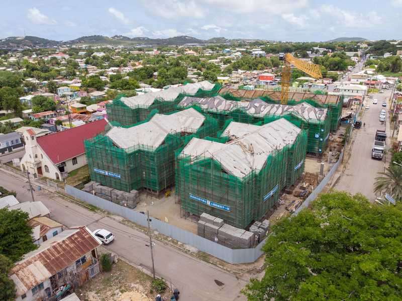
Booby Alley housing redevelopment under construction

Construction of the new Booby Alley/Pelican Court housing development in The Point.

The replacement development is being financed through a major grant from the People’s Republic of China.

Published figures have varied depending on the year and whether officials were referring to the Booby Alley phase alone or the larger Chinese-supported housing programme. The 2025 Budget Statement put the Booby Alley Housing Development at approximately EC$60 million, while other public statements have cited considerably higher figures when associated works and programmes are included.

The development now comprises 150 condominium-style homes. Government describes them as modern, climate-resilient housing with substantially improved infrastructure.

Former property owners are expected to receive priority. Prime Minister Gaston Browne has indicated that former owners may receive replacement apartments through a swap arrangement. Remaining apartments are expected to be allocated primarily through mortgages or other structured forms of ownership.

The old name is also disappearing. Browne has suggested Pelican Court as the name of the new community.

A very different kind of community

What is being planned for Pelican Court differs significantly from the relatively informal community that existed there before.

In August 2026, Browne said the development could include two resident property managers, an administrative office, formal rules governing maintenance and resident behaviour and potentially a permanent police outpost staffed by two officers at a time.

The Prime Minister has also raised the prospect of a community or property-management charge to pay for common expenses. Those expenses could include maintenance of shared areas and infrastructure such as sewage and wastewater systems.

Browne even suggested that such fees might ultimately be collected through utility bills because homeowner associations at some previous government developments have had difficulty collecting maintenance contributions.

The result is therefore not simply a change from wooden houses to concrete condominiums. It is a shift from a historically informal, densely connected neighbourhood to a formally managed residential complex with rules, fees, managers and potentially a permanent police presence.

The cruise-port transformation next door
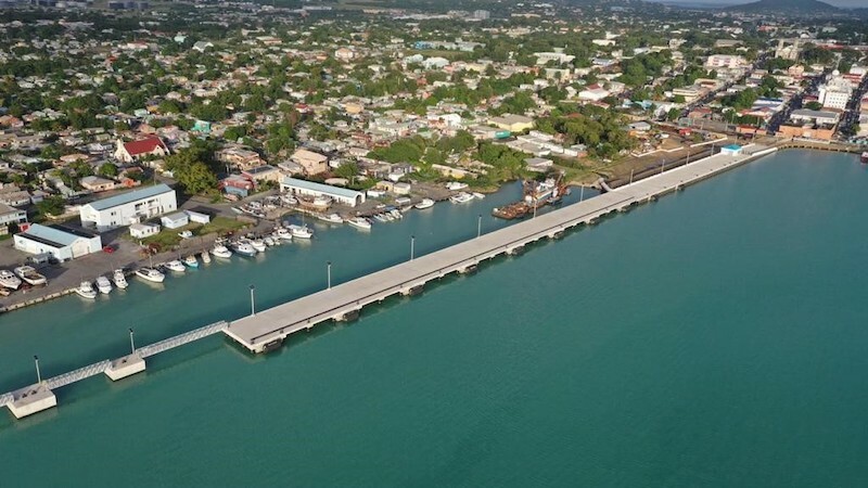
Antigua Cruise Port fifth berth in St John's

The fifth cruise berth at St John’s. The adjoining waterfront and upland area form part of the much larger transformation of the harbour edge.

Pelican Court cannot be viewed entirely in isolation from what is happening along the neighbouring shoreline.

The St John’s cruise-port redevelopment has transformed the western waterfront of the capital. An environmental study prepared for the St John’s redevelopment describes the fifth berth, completed in 2020, and identifies approximately 20,000 square metres of land behind the pier for further development.

The same environmental study describes the surrounding district as a mixed residential and commercial area containing private homes, shops, bars, restaurants and other businesses. It also records that properties surrounding the development had been acquired and that much of the project land had been cleared.

The next stages of the upland cruise development have included plans for restaurants, retail, entertainment facilities, passenger amenities, pool and cabana areas and associated tourism infrastructure.

The fifth berth alone was widely reported as a roughly US$30 million project.

Hundreds of millions of dollars in one small part of St John’s

Prime Minister Browne has himself grouped these developments together when discussing the transformation of Point and Villa.

He has said that more than EC$500 million was invested in the cargo and cruise ports, that Global Ports represented another EC$100 million-plus investment, and has cited close to another EC$100 million in relation to the Booby Alley redevelopment when discussing the wider programme.

He has put these projects at roughly EC$700 million and suggested that, when other investments and concessions are included, investment in the Point and Villa area approaches EC$1 billion.

This makes the redevelopment of Booby Alley particularly significant.

A community historically associated with poverty and neglect now occupies land immediately beside an increasingly valuable cruise-tourism waterfront.

Urban renewal — or something more complicated?

There is a strong case in favour of the project.

Many of the old houses were in poor condition. Modern sanitation, stronger buildings, improved drainage, climate resilience and secure home ownership can materially improve residents’ quality of life.

If former residents become owners of valuable modern apartments, the project could also represent a significant increase in household wealth.

But there are equally legitimate questions about displacement, cultural continuity, social control and gentrification.

For several years, the original community was physically dispersed while the site was cleared. Some residents resisted the process. The new development will operate under a much more formal management structure.

At exactly the same time, the surrounding waterfront is becoming increasingly valuable because of cruise tourism, port expansion and associated commercial development.

The important question is therefore not simply whether Pelican Court is physically better than Booby Alley. In terms of buildings, sanitation and infrastructure, it almost certainly will be.

The deeper question is this: will the people whose families created the social and cultural history of Booby Alley remain the principal beneficiaries of the enormous increase in value now taking place around them?

Questions that still deserve answers

A complete picture would require a parcel-by-parcel examination of this part of St John’s.

  • Who owned the land before redevelopment?
  • Which properties were purchased or compulsorily acquired, and what compensation was paid?
  • Where did every displaced household go?
  • How many original Booby Alley families will actually return to Pelican Court?
  • What ownership rights will returning families have in the new condominiums?
  • Who owns and controls the increasingly valuable commercial and waterfront land surrounding the community today?

And perhaps one other question deserves attention: how will the history of Booby Alley itself be preserved?

H.D. Anderson O’Marde argued years ago that the community’s contribution should not simply disappear from Antigua’s history and suggested that some form of permanent memorial should recognise its people and achievements.

That may prove especially important now.

The physical Booby Alley is disappearing. Pelican Court is taking its place. What remains to be seen is whether this transformation will preserve not only the people, but also the memory and identity of one of St John’s most historically significant working-class communities.


Sources & Further Reading

Note: Historical descriptions, project costs and numbers of affected households vary somewhat between official documents and contemporary reporting. Where figures differ, they should be understood in the context of the particular project phase or government statement being discussed.

Thursday, August 13, 2026

Jolly Harbour Beach Access info


The following post is being shared on WhatsApp groups and I think it's worth having a read to see how the issue of Jolly Harbour Beach access has come to pass and why there's a petition to the county's Prime Minister.

What the Available Documentary Record Appears to Show About Public Access and South Finger Parking

A note about the documents

This chronology has been assembled from a mixture of publicly available records, historical material and copies of documents that have circulated among Jolly Harbour homeowners and other interested persons.

Where a document is an official or publicly available record, it is described accordingly.

Where a document has circulated privately and its original source or provenance has not been independently verified, it is referred to only as a document that purports to be what it appears on its face to be.

Nothing in this article should therefore be taken as authenticating any privately circulated document, establishing its completeness, or suggesting how or from whom any particular copy was originally obtained.

Nor does this article seek to determine questions of land ownership, private legal rights, contractual obligations or the motives of any individual, company or public authority.

Its purpose is much simpler:

to place the presently available material in chronological order and identify the questions that appear to arise from it.


The central question

The present controversy over access and parking at Jolly Harbour Beach is sometimes presented as though residents are simply objecting to the loss of somewhere they became accustomed to parking.

The material presently available suggests that the history may be considerably more substantial.

Read chronologically, the historical masterplan, Government records, contemporary communications, material relating to South Finger and the Nikki Beach Environmental and Social Impact Assessment appear to describe a longstanding pattern of access and parking associated with Jolly Harbour Beach.

That does not necessarily establish a legal right to continue parking on any particular parcel of privately owned land.

It does, however, raise a legitimate planning and historical question:

If a longstanding parking facility serving existing users of Jolly Harbour Beach is no longer to be available in its previous form, what equivalent provision, if any, is being made for those users?


1. The original Jolly Harbour development

The logical starting point is the historical Jolly Harbour masterplan.

The plan depicts Jolly Harbour as an integrated development rather than simply a collection of individually owned houses.

Of particular relevance is the southern end of the development.

The historical plan appears to show a substantial route extending from within Jolly Harbour towards Jolly Harbour Beach and opening into a considerably wider area as it approaches the beach.

Whatever the precise legal status of the individual areas depicted on that plan, its physical layout provides useful historical context for the way in which Jolly Harbour subsequently developed.

For many years residents, visitors and members of the wider public were in practice able to travel through the southern part of Jolly Harbour and reach the beach.

Jolly Harbour subsequently grew to encompass more than 800 property owners, together with tenants, guests and visitors.

Members of the wider public, tourists, taxis and vendors also used the southern access.

The relevance of this history is not that long use automatically establishes ownership of somebody else's land or creates a private legal right.

It is simply that access to Jolly Harbour Beach formed part of the practical environment within which Jolly Harbour developed and hundreds of people purchased property.

The original Government transaction by which the development lands were made available to Dr Erhart and the original developers would therefore be useful historical material to locate.

There have been references to nominal consideration of $1.

Until the original Government documentation is obtained and verified, however, that figure should not be treated as established fact.

If the primary documentation ultimately confirms it, the terms and any accompanying development or public obligations could then be examined on their own merits.


2. The practical position over subsequent decades

Whatever the precise legal status of every part of the land, there appears to be little controversy about the practical position that developed over the following years.

Jolly Harbour homeowners used the southern route to reach Jolly Harbour Beach.

Members of the public also reached the beach through the area.

Tourists visited.

Taxis brought passengers.

Vendors operated.

Vehicles parked close to the beach.

The importance of this history is that the events of 2019 did not occur against a blank canvas.

By then there was an established pattern of actual use which provides the context in which the later documents should be read.


3. September 2019  a document referring to a “South Finger Parking Agreement”

Among material that has circulated is documentation referring to an agreement dated 13 September 2019 and describing it as the:

“South Finger Parking Agreement.”

The complete underlying agreement is not presently available for examination and its precise terms should therefore not be assumed.

Other material presently in circulation appears on its face to refer back to that agreement and to record substantial sums associated with it.

Those figures appear to be approximately:

US$550,000 already advanced, with approximately US$1.1 million remaining to be paid.

Until the underlying agreement and its provenance are independently confirmed, no conclusion should be drawn about precisely what rights or property were being acquired.

Nevertheless, the terminology appearing in the material is potentially significant.

If authentic, it would demonstrate that the expression “South Finger Parking Agreement” was being used contemporaneously in a substantial commercial context rather than being a description subsequently invented by homeowners.

Obtaining and verifying the complete agreement would therefore considerably assist in understanding the history.


4. November 2019 reference to the “South Finger parking lot”

Another document presently in circulation purports to be a contemporaneous email concerning a prospective purchaser's plans for the South Finger.

On its face, the email refers to:

“the draft plan the prospective buyer of the South Finger parking lot has presented to us this week.”

The document also appears to state:

“We are happy with the plan as it solves the issues raised by the home owners as we see it.”

If authentic and complete, the terminology is noteworthy.

The area is expressly described as the “South Finger parking lot”, and the proposed plan appears to have been considered in the context of issues previously raised by homeowners.

The document should not be taken further than that without verification.

It does, however, identify another obvious piece of material worth obtaining in original form: the draft plan to which the email apparently refers.


5. 26 November 2019
communication concerning South Finger parking

A further communication that has circulated among homeowners appears to date from 26 November 2019.

On its face, it refers expressly to:

“an area that exists that we call the south finger parking which is where much of this traffic is to be funnelled.”

The communication appears to discuss seasonal traffic associated with cruise-ship guests, taxis and buses.

It also refers to the possibility of additional housing on the property and states that the contemplated plan would:

“construct a substantial amount of added parking on properly constructed parking lots.”

If the document is authentic and complete, its significance is straightforward.

It would indicate that homeowners were being informed at that time that development of South Finger was contemplated but that substantial additional parking was also contemplated as part of that redevelopment.

That naturally raises a question:

What became of that proposed additional parking?


6. November 2019  the Government compulsory acquisition process

Here the chronology moves onto firmer public documentary ground.

Government records concerning South West Registration Section, Block 55 1186A, Parcel 836, approximately 0.19 acres, record a proposed compulsory acquisition.

The stated purpose recorded in the relevant Government documentation was:

“for a public purpose, namely for use as a recreational ground by members of the public.”

Parliament subsequently considered and approved the proposed acquisition.

Contemporary public reporting also discussed the issue in the context of access to Jolly Harbour Beach.

Care is required in interpreting this.

The proposed compulsory acquisition does not, by itself, establish private parking or access rights over other parcels.

Nor does it determine the legal status of the South Finger parking area.

What it does demonstrate is that Government formally commenced a compulsory acquisition process involving land in the area for an expressly stated public recreational purpose.

That provides important contemporary context.


7. December 2019  contemporary discussion of public beach access

Contemporary public reporting around the same period records Government representatives discussing public access to beaches.

The Attorney General was reported as referring to the importance of free and easy beach access.

There were also reports of DCA involvement concerning access arrangements at Jolly Harbour.

Those reports should be treated according to their precise wording.

They do not establish private rights over individual parcels of land.

They do, however, provide further context for the Government's decision to pursue compulsory acquisition for the expressly stated public recreational purpose.


8. 2020 a document purporting to be a Non-Binding Letter of Intent concerning CDAL

Another document presently circulating among homeowners and interested persons purports to be a 2020 Non-Binding Letter of Intent concerning the proposed acquisition of CDAL.

Its provenance and completeness have not been independently verified for the purposes of this article.

It should therefore be considered only for what it appears on its face to record.

The document appears to refer to a proposed share purchase price of approximately US$29.35 million.

Separately, it contains a section apparently headed:

“Concurrent Closing of South Finger Parking”

It also appears expressly to refer back to a 13 September 2019 South Finger Parking Agreement.

The document records figures of approximately US$550,000 already advanced and approximately US$1.1 million remaining to be paid.

If authentic, this would appear to show that South Finger parking was being dealt with separately within the documentation surrounding a much larger proposed corporate acquisition.

But without the complete underlying agreement and confirmation of the provenance of the documents, it would be inappropriate to draw conclusions about precisely what was being bought, sold or promised.

The proper course is to obtain the underlying documentation and establish the facts.


9. 2020  Government abandons the proposed acquisition

The Government's subsequent decision is again recorded in an official public document.

An Official Gazette notice records the abandonment, under section 10 of the Land Acquisition Act, of the intended acquisition of Parcel 836.

Importantly, the Gazette refers back to the original declaration and repeats that the intended acquisition had been:

“for a public purpose, namely for use as a recreational ground by members of the public.”

The proposed acquisition therefore did not proceed.

The documentary record presently available does not appear to explain why.

It would be inappropriate to speculate that the abandonment was connected with any particular private transaction unless and until documents demonstrate that connection.

Instead, the chronology raises a straightforward question:

Why was the compulsory acquisition abandoned, and was any alternative arrangement, assurance, easement or other provision put in place concerning public recreational access?

The relevant Cabinet papers, Government correspondence or other contemporary records may provide the answer.

Until they are obtained, it remains an unanswered question.


10. What happened after the acquisition was abandoned?

This appears to be one of the most important gaps in the chronology.

Government had commenced an acquisition for a stated public recreational purpose.

Parliament had approved it.

Government subsequently abandoned it.

Yet in practical terms, Jolly Harbour Beach continued to be accessed through the area and the South Finger car park continued operating.

That sequence naturally raises the question:

Was some alternative arrangement considered sufficient at the time to accommodate continued public access and/or parking?

There may have been an easement.

There may have been an undertaking.

There may have been a planning arrangement.

There may have been some other agreement.

Equally, there may have been no such arrangement.

Without the relevant documentation, nobody should assume the answer.

Finding those documents should therefore be a priority.


11. December 2023 and January 2024 the EIA records what was actually happening

The chronology then moves forward more than three years.

The Environmental and Social Impact Assessment prepared in connection with the Nikki Beach development records baseline observations undertaken on:

12 December 2023, and
10 January 2024.

Unlike recollections about what happened decades earlier, these are contemporary recorded observations of conditions shortly before the proposed redevelopment.

The assessment records activity associated with the beach access area, including vendors, tourists, taxis, deliveries and beach businesses.

Most importantly for the parking issue, it records the car park in actual use.

The assessment states that by 10:00am:

“the carpark had mostly filled up with cars.”

That observation is important without needing to add anything to it.

It demonstrates that, at the time of the baseline observations, a car park in the area was actively being used.

It therefore provides a useful factual baseline against which the parking implications of the proposed development can be considered.


12. The proposed Nikki Beach development

The EIA describes a substantial proposed development comprising approximately:

- 184 residential units;
- 82 hotel rooms;
- a beach club;
- restaurants;
- a spa; and
- associated facilities.

The material identifies approximately 150 parking spaces.

Those spaces will necessarily have to accommodate at least some of the parking demand generated by the development itself, including residents, hotel guests, customers, employees, servicing and deliveries.

But the EIA's own baseline observations also record parking demand that existed before the proposed development.

The car park was already being used by people accessing the area.

That creates an obvious planning question:

How has that pre-existing parking demand been taken into account?


13. The apparent gap in the EIA

An environmental and social assessment records baseline conditions so that the potential effects of a proposed development can be considered against what existed beforehand.

Here, the baseline records an actively used car park.

The proposed development will itself generate additional traffic and parking demand.

If some or all of the parking previously available to beach users is no longer to remain available in its previous form, the question becomes what happens to that existing demand.

From the material presently available, it is difficult to identify a detailed assessment addressing:

- where vehicles previously using the area are expected to park;
- whether equivalent replacement parking is proposed;
- the consequences of displacement onto other parts of Jolly Harbour;
- accessibility for elderly or mobility-impaired beach users;
- the effect upon Jolly Harbour homeowners and their guests;
- the effect upon members of the wider public;
- the effect upon taxis, vendors and tourists; and
- the location and capacity of any replacement parking intended for existing beach users.

There may be further planning documents that address these matters.

If so, they should form part of the discussion.

If not, the absence of an identifiable answer appears to be a legitimate planning question.


14. The modern planning context

Recent environmental and planning material in Antigua appears to recognise the importance of public beach access and the relevance of existing or traditional patterns of use when assessing development proposals.

The precise legal and planning consequences for Jolly Harbour Beach are matters for the appropriate authorities and, where necessary, legal advice.

Nothing in this chronology suggests that historical use automatically gives every homeowner or member of the public a private legal right to park on a particular parcel.

That is not the point.

The narrower question is whether existing patterns of access and parking should have been identified, assessed and appropriately accommodated when considering a major redevelopment.

At Jolly Harbour Beach, the historical and contemporary material appears to provide unusually substantial evidence that such use existed.


15. What the chronology presently appears to show

Subject always to verification of privately circulated material, the available documentary picture can be summarised as follows.

Original development

The historical masterplan provides the physical context of an integrated Jolly Harbour development with substantial access towards Jolly Harbour Beach.

Following decades

Residents, visitors, members of the public, tourists, taxis and vendors use the southern area to reach the beach, with vehicles parking close to it.

September 2019

Material subsequently circulated refers to an agreement dated 13 September 2019 described as the “South Finger Parking Agreement.”

November 2019

A circulated document purporting to be a contemporary email refers to the “South Finger parking lot” and a prospective purchaser's plan said to address issues raised by homeowners.

26 November 2019

Another circulated communication appears to refer expressly to “south finger parking” and to plans for a “substantial amount of added parking.”

27 November 2019

Government commences a compulsory acquisition process concerning Parcel 836 for an expressly stated public recreational purpose.

December 2019

Parliament approves the proposed acquisition against a background of public discussion concerning beach access.

2020

A document circulating among interested persons, purporting to be a Non-Binding Letter of Intent concerning the proposed acquisition of CDAL, appears separately to recognise the South Finger Parking Agreement and substantial sums associated with it.

2020

Government subsequently abandons the proposed compulsory acquisition.

The reason, and whether any alternative access arrangement was contemplated, remain matters requiring documentary clarification.

December 2023 / January 2024

The EIA baseline observations record the car park operating and state that by 10:00am it had “mostly filled up with cars.”

Proposed development

A substantial residential, hotel and hospitality development is proposed with approximately 150 parking spaces.

The question remains whether and where equivalent provision is being made for the pre-existing parking demand recorded in the EIA baseline.


The issue in plain English

Nobody needs to claim ownership of somebody else's land to ask these questions.

Nobody needs to argue that Jolly Harbour can never change.

Nobody needs to attribute improper motives to Government, CDAL, a purchaser or the Nikki Beach developer.

And none of this requires opposition to Nikki Beach.

The documentary history can simply be allowed to speak for itself.

For many years people accessed Jolly Harbour Beach through this area and parked close to the beach.

Documents presently in circulation appear to show that the expressions “South Finger parking,” “South Finger parking lot” and “South Finger Parking Agreement” were being used in 2019 and 2020.

Government's own public records show that it commenced compulsory acquisition of nearby land for an expressly stated public recreational purpose and subsequently abandoned that acquisition.

And the EIA provides contemporary recorded evidence that the car park was still operating in December 2023 and January 2024, including the observation that it had “mostly filled up with cars” by 10:00am.

Those facts and documents may ultimately have explanations that are not presently available.

That is precisely why the questions should be asked rather than conclusions assumed.

The central question is therefore a simple one:

If parking documented as serving existing users of Jolly Harbour Beach before the proposed development is no longer to be available in its previous form, what equivalent provision, if any, is being made for those existing beach users?

And alongside it sits an equally important historical question:

When Government abandoned its proposed compulsory acquisition for a stated public recreational purpose in 2020, was any alternative arrangement made to preserve or accommodate that public use?

If the relevant documents exist, producing them could answer much of the present controversy.

This is not an argument against development.

It is a request to understand the documentary history, fill the gaps in that history, and ensure that new development properly considers what was already there.